 Table of Contents
Table of Contents
Table of Contents
Mapping application is used to view spatial features.
The map view can be added to run pages using several different size modules in Layout Manager. Different map layers can be assigned to different run pages.
Use these features to adjust map preferences:
|
|
|
|
Zoom changes the amount of field viewed on the map.
|
Zoom Out - View moves further away from the machine. |
|
|
Zoom In - View moves closer to the machine. |
|
|
|
|
|
Zoom changes the amount of field viewed on the map.
|
Zoom Out - View moves further away from the machine. |
|
|
Zoom In - View moves closer to the machine. |
|
|
Heading displays the direction of travel in cardinal directions and degrees. 0° equals North, 90° - East, 180° - South, and 270° - West. |
|
|
Guidance Line Counter displays the current active guidance track in relation to Track 0. |
|
NOTE: The maximum line count is 999.
The selected map layer is displayed on the top left of the map module. When multiple operations are present, select the operation toggle to view the map layer for each operation.
|
Select the Swap Layer button to toggle between map layers. |
|
|
Compass indicates cardinal direction on the map. Select the compass icon to toggle between Machine Heading Up and North Up modes. |
|
By default, the compass is in Machine Heading Up mode, where the machine heading is at the top of the screen and the view rotates with the machine heading (similar to Perspective View).
In North Up mode, north is always at the top of the screen, and the view does not rotate with the machine heading (similar to fixed field view).
NOTE: Some smaller map modules will not have the capability for gestures due to their size.
Pinch in with two fingers to zoom in.
Pinch out with two fingers to zoom out.
One-finger zoom: Double-tap screen with one finger, hold, then drag finger up and down to zoom in or out.
Double-tap screen with one finger to zoom in one level.
Single-tap screen with two fingers to zoom out one level.
Pan across the map by dragging one finger across the screen.
Beginning with the finger off the display edge, swipe left to view the next run page in the run page set. Swipe right to view the previous run page.
Split Map allows the operator to view two layers of a map at the same time.
|
Select the Split Map button to split the map view. |
|
|
Select the Merge Split Map button to merge a split map screen back into a single map. |
|
Panning or zooming on one map screen also pans or zooms the second map screen.
|
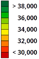
Select the Legend button to open the map legend. |
|
|
Select the map legend to edit interval values. |
|
|
Select New Work to clear work data from the map. |
|
|
Select Source Directions to view the direction of travel for the machine that recorded the source operation. Arrows on the guidance lines indicate the path. |
|
Select the AutoTrac Turn Automation help for information about the controls that are shown on the map.